Detailed Weekend Forecast
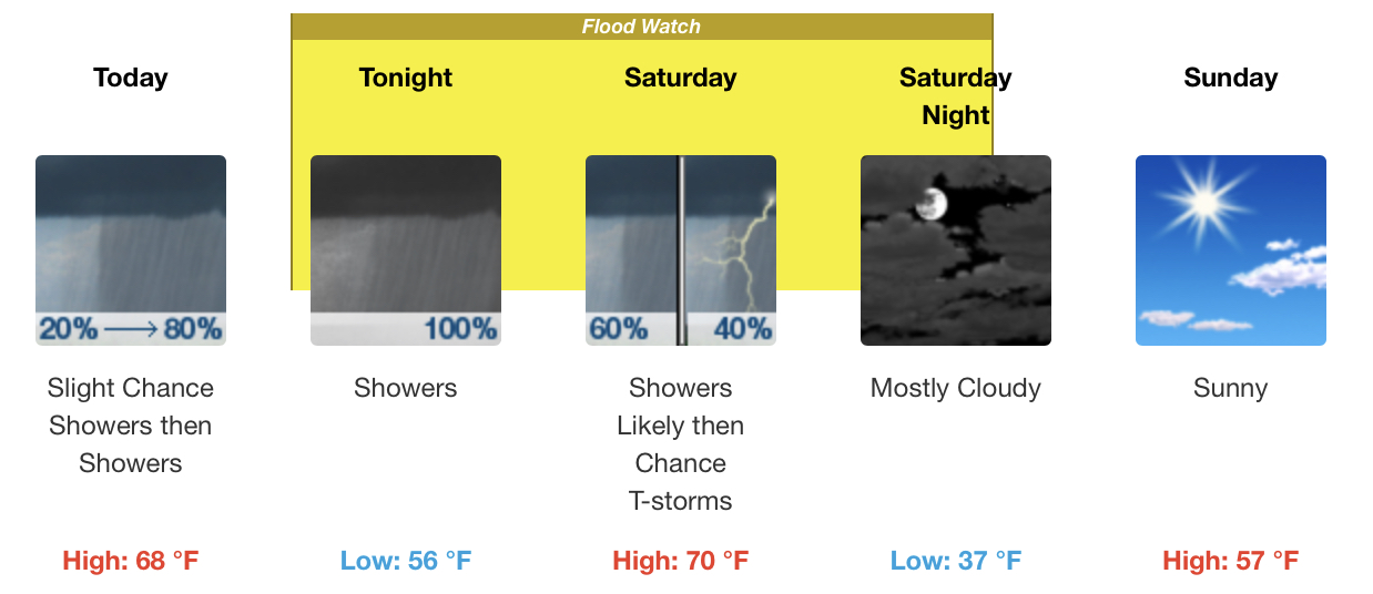
Today
Showers, mainly after 3pm. High near 68. Southeast wind 5 to 15 mph, with gusts as high as 25 mph. Chance of precipitation is 80%. New precipitation amounts between a quarter and half of an inch possible.
Tonight
Showers, with thunderstorms also possible after 10pm. Low around 56. Southeast wind 15 to 20 mph, with gusts as high as 30 mph. Chance of precipitation is 100%. New rainfall amounts between 1 and 2 inches possible.
Saturday
Showers likely and possibly a thunderstorm before 8am, then a chance of showers and thunderstorms between 8am and 4pm, then a slight chance of showers after 4pm. Mostly cloudy, with a high near 70. Southeast wind 5 to 15 mph becoming west in the afternoon. Winds could gust as high as 20 mph. Chance of precipitation is 60%. New rainfall amounts between a tenth and quarter of an inch, except higher amounts possible in thunderstorms.
Saturday Night
Mostly cloudy, with a low around 37. Northwest wind 10 to 15 mph, with gusts as high as 20 mph.
Sunday
Sunny, with a high near 57. Northwest wind 10 to 15 mph, with gusts as high as 20 mph.
Sunday Night
Partly cloudy, with a low around 33.
Flood Watch
Dade-Walker-Catoosa-Whitfield-Murray-Fannin-Gilmer-Union-Towns-
Chattooga-Gordon-Pickens-Dawson-Lumpkin-White-Floyd-Bartow-
Cherokee-Forsyth-Hall-Banks-Jackson-Madison-Polk-Paulding-Cobb-
North Fulton-Gwinnett-Barrow-Clarke-Oconee-Oglethorpe-Wilkes-
Haralson-Carroll-Douglas-South Fulton-DeKalb-Rockdale-Walton-
Newton-Morgan-Greene-Taliaferro-Heard-Coweta-Fayette-Clayton-
Spalding-Henry-Butts-Jasper-Putnam-Hancock-Warren-Troup-
Meriwether-Pike-Upson-Lamar-Monroe-Jones-Baldwin-Washington-
Glascock-Jefferson-Harris-Talbot-Taylor-Crawford-Bibb-Twiggs-
Wilkinson-Muscogee-Chattahoochee-Marion-Schley-Macon-Peach-
Houston-Stewart-
Including the cities of , Riverdale, Eatonton, Rome, Franklin,
Newnan, Jasper, East Point, Gainesville, Blairsville, Thomaston,
Douglasville, Winder, Dallas, Atlanta, Butler, Ellijay, Sparta,
West Point, Pine Mountain, Warrenton, Monticello, Fort Valley,
Chatsworth, Jackson, Cleveland, Decatur, Toomsboro, Montezuma,
Athens, Hiawassee, Columbus, Commerce, Milledgeville,
Cartersville, Barnesville, Madison, Macon, Fort Moore, Gray,
Peachtree City, Conyers, Forsyth, Monroe, Trenton, Woodstock,
Dawsonville, Fort Oglethorpe, Comer, Ellaville, Calhoun,
Carrollton, Jeffersonville, LaFayette, Bremen, Stockbridge,
Watkinsville, Talbotton, Dalton, Crawford, Manchester, Roberts,
Cumming, Louisville, Warner Robins, Dahlonega, Sandersville,
Lumpkin, Greensboro, Washington, Crawfordville, GIbson, Marietta,
Lawrenceville, Zebulon, Summerville, Homer, Buena Vista, Griffin,
Cedartown, and Covington
248 AM EST Fri Mar 8 2024

...FLOOD WATCH REMAINS IN EFFECT FROM THIS EVENING THROUGH LATE
SATURDAY NIGHT...

* WHAT...Flash flooding caused by excessive rainfall continues to be
  possible.

* WHERE...Portions of central, east central, north central,
  northeast, northwest, and west central Georgia, including the
  following areas, in central Georgia, Baldwin, Bibb, Butts,
  Crawford, Houston, Jasper, Jones, Monroe, Peach, Putnam, Twiggs
  and Wilkinson. In east central Georgia, Glascock, Greene, Hancock,
  Jefferson, Taliaferro, Warren, Washington and Wilkes. In north
  central Georgia, Barrow, Cherokee, Clayton, Cobb, Dawson, DeKalb,
  Douglas, Fannin, Fayette, Forsyth, Gilmer, Gwinnett, Hall, Henry,
  Lumpkin, Morgan, Newton, North Fulton, Pickens, Rockdale, South
  Fulton, Union and Walton. In northeast Georgia, Banks, Clarke,
  Jackson, Madison, Oconee, Oglethorpe, Towns and White. In
  northwest Georgia, Bartow, Carroll, Catoosa, Chattooga, Dade,
  Floyd, Gordon, Haralson, Murray, Paulding, Polk, Walker and
  Whitfield. In west central Georgia, Chattahoochee, Coweta, Harris,
  Heard, Lamar, Macon, Marion, Meriwether, Muscogee, Pike, Schley,
  Spalding, Stewart, Talbot, Taylor, Troup and Upson.

* WHEN...From this evening through late Saturday night.

* IMPACTS...Excessive runoff may result in flooding of rivers,
  creeks, streams, and other low-lying and flood-prone locations.
  Area creeks and streams are running high and could flood with more
  heavy rain.

* ADDITIONAL DETAILS...
  - A storm system will produce moderate to heavy rainfall in the
    region between Friday night and Saturday night. Rainfall
    totals of 2 to 5 inches are expected, with locally higher
    amounts possible. This rainfall combined with saturated soil
    conditions will likely produce flooding.
  - http://www.weather.gov/safety/flood