The United States Geological Survey reported an earthquake Monday afternoon in Georgia.
According to the United States Geological Survey, a 2.2 magnitude quake happened at 4:49 p.m. just west of Dalton near Tunnel Hill.
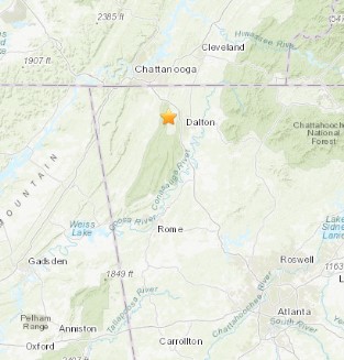
The reported 2.2 magnitude quake with had a 13.7 kilometer depth.
More Information:
Earthquakes in the Eastern Tennessee Seismic Zone
The Eastern Tennessee seismic zone extends across Tennessee and northwestern Georgia into northeastern Alabama. It is one of the most active earthquake areas in the Southeast. Although the zone is not known to have had a large earthquake, a few earthquakes in the zone have caused slight damage. The largest known (magnitude 4.6) occurred on April 29, 2003, near Fort Payne, Alabama. Earthquakes too small to cause damage are felt about once a year. Earthquakes too small to be felt are abundant in the seismic zone, and seismographs have recorded hundreds of them in recent decades.
Earthquakes in the central and eastern U.S., although less frequent than in the western U.S., are typically felt over a much broader region. East of the Rockies, an earthquake can be felt over an area as much as ten times larger than a similar magnitude earthquake on the west coast. A magnitude 4.0 eastern U.S. earthquake typically can be felt at many places as far as 100 km (60 mi) from where it occurred, and it infrequently causes damage near its source. A magnitude 5.5 eastern U.S. earthquake usually can be felt as far as 500 km (300 mi) from where it occurred, and sometimes causes damage as far away as 40 km (25 mi).
Faults
Earthquakes everywhere occur on faults within bedrock, usually miles deep. Most of eastern Tennessee’s bedrock originated several hundred million years ago, as the Appalachian Mountains were formed.
At well-studied plate boundaries like the San Andreas fault system in California, often scientists can determine the name of the specific fault that is responsible for an earthquake. In contrast, east of the Rocky Mountains this is rarely the case. The Eastern Tennessee seismic zone is far from the nearest plate boundaries, which are in the center of the Atlantic Ocean and in the Caribbean Sea. The Eastern Tennessee seismic zone is laced with known faults but numerous smaller or deeply buried faults remain undetected. Even the known faults are poorly located at earthquake depths. Accordingly, few, if any, earthquakes in the Eastern Tennessee seismic zone can be linked to named faults. It is difficult to determine if a known fault is still active and could slip and cause an earthquake. As in most other areas east of the Rockies, the best guide to earthquake hazards in the seismic zone is the earthquakes themselves.


Bulloch Public Safety
04/02/2026 Booking Report for Bulloch County

Chattooga Local News
GBI Arrests Former Teacher in Murray County
Bulloch Public Safety
04/01/2026 Booking Report for Bulloch County

Chattooga Local News
Oak Hill and The Martha Berry Museum’s Next Family Morning to Occur on April 8

Chattooga Schools
2027 Georgia Teacher of the Year finalists announced
Bulloch Public Safety
03/09/2026 Booking Report for Bulloch County
Bulloch Public Safety
03/30/2026 Booking Report for Bulloch County
Bulloch Public Safety
03/16/2026 Booking Report for Bulloch County
Bulloch Public Safety
03/10/2026 Booking Report for Bulloch County
Bulloch Public Safety
03/20/2026 Booking Report for Bulloch County