Trion, Georgia — The Chattooga County Emergency Management Agency contacted the National Weather Service (NWS) Peachtree City office in Atlanta this morning regarding the storm event that impacted portions of the City of Trion on Monday, September 21, 2026.
Following an analysis of the storm, the National Weather Service determined that the damage was associated with a downburst, likely a wet microburst, rather than a tornado.

According to the National Weather Service, the storm began developing at approximately 4:15 p.m. and rapidly increased in vertical extent over the following 15 minutes, reaching approximately 40,000 feet in height directly over the Trion area. The storm then quickly collapsed, essentially falling apart within the next 20 minutes.
The National Weather Service explained that this type of rapid storm development and collapse can produce what is known as a wet microburst. A wet microburst occurs when rain-cooled air rapidly descends from a thunderstorm and strikes the ground, spreading outward and producing strong, straight-line winds over a relatively small area.
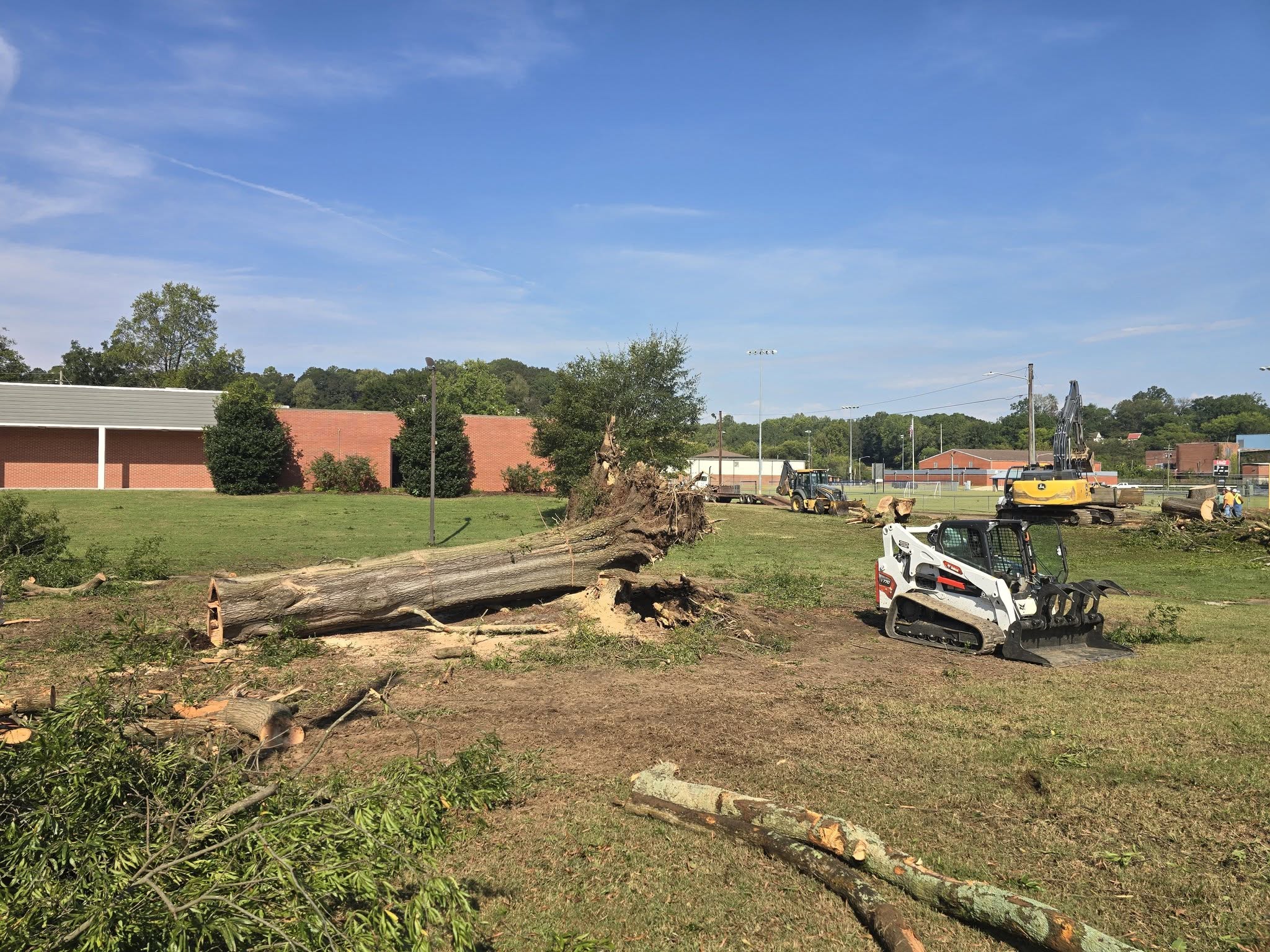
The NWS estimates that winds associated with this type of event can reach approximately 60 to 70 mph over a small area. These winds can knock down trees, move unsecured objects and cause damage to structures, including minor roof damage, generally within a relatively small area. Unfortunately, the Trion area was located almost directly beneath where this downburst occurred.
Why There Was No Tornado Warning
The National Weather Service confirmed that downbursts can be particularly difficult to detect and warn because radar primarily detects horizontal motion within a storm. The strongest damaging winds from a downburst occur when the air descends rapidly and then spreads outward after reaching the ground.
The closest radar imagery reviewed by the NWS was from the radar site in Hytop, Alabama. The lowest radar scan did not show winds exceeding approximately 10–15 mph within the storm. However, that lowest radar scan was more than a mile above the ground. The damaging horizontal winds that occurred as the descending air reached the surface were therefore not directly visible in the radar data. There was no rotation associated with this storm system, which is why a tornado warning was not issued, and tornado sirens were not activated.
What Is a Downburst?
A downburst is a powerful column of sinking air from a thunderstorm that reaches the ground and rapidly spreads outward in all directions, producing damaging straight-line winds.
Downbursts can develop through several processes: a heavy precipitation core, where a strong thunderstorm can contain a significant amount of rain and hail in its upper levels; descending air, where as the storm’s updraft weakens, the precipitation and surrounding cold air can rapidly descend toward the ground; evaporative cooling, where rain or hail passing through drier air can evaporate, cooling the air and making it denser, which can cause the air to descend even more rapidly; and surface impact, where the rapidly descending air reaches the ground and spreads outward horizontally, producing strong straight-line winds.
A microburst is a type of downburst that generally affects an area less than approximately 2.5 miles across and typically lasts only several minutes. Despite its small size and short duration, a microburst can produce significant damage.
Damage Report
Chattooga County E-911 received 17 calls during and immediately following the storm reporting trees down, with some reports involving power lines.
Chattooga County Emergency Management personnel conducted damage assessments today and identified several residences affected by falling trees. At this time, four residences have been identified as having tree-related damage, including both minor and more significant structural damage. Additional homeowners are still being contacted to determine the full extent of the damage.
Chattooga County Public Works, the City of Summerville Maintenance Department and several local tree service companies have assisted with cleanup and debris removal following the storm. The Emergency Management Agency continues to work with residents and local agencies to document the damage and assist with the response.
Report Storm Damage
If your home was damaged by the storm and you have not yet spoken with Chattooga County Emergency Management, please contact Pamela Vaughn, Director of Chattooga County Emergency Management Agency, at 706-857-3400, Option 2.
Residents are encouraged to report storm-related damage so that it can be properly documented as recovery efforts continue.
Pamela Vaughn Director Chattooga County Emergency Management Agency




Chattooga Local News
Chattooga County EMA Provides Update on Storm Damage in Trion

Chattooga Local News
Gov. Kemp: Pirelli to Invest $1.2 Billion in Rome Georgia Expansion

Bulloch Public Safety
09/21/2026 Booking Report for Bulloch County


Chattooga Lifestyle
52nd Annual Sum Nelly Festival Returns to Summerville October 3rd
Bulloch Public Safety
08/31/2026 Booking Report for Bulloch County
Bulloch Public Safety
08/24/2026 Booking Report for Bulloch County
Bulloch Public Safety
09/08/2026 Booking Report for Bulloch County
Bulloch Public Safety
09/14/2026 Booking Report for Bulloch County
Bulloch Public Safety
09/04/2026 Booking Report for Bulloch County